SCEC Workshop: Earthquakes and Related Hazards in the Santa Barbara-Ventura Area

Commemorating the 1925 Santa Barbara Earthquake

Date: June 29-30, 2025
Location: University of California, Santa Barbara
Workshop Organizers: Chen Ji (UCSB), Craig Nicholson (UCSB)  and Tom Rockwell (SDSU)
SCEC Award: 25139

APPLICATION DUE: April 21, 2025
The participant list will be finalized by April 28, 2025.
Overview

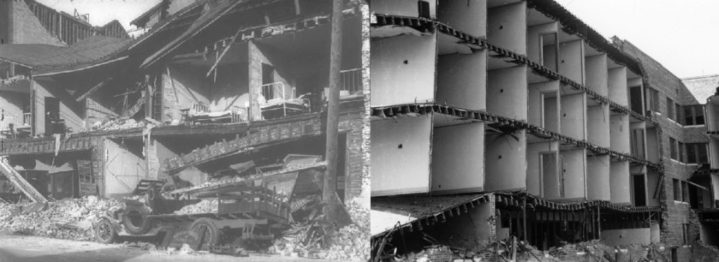
On June 29-30, 2025, UC Santa Barbara will host a field trip and workshop to mark the centennial of the 1925 M6.5 Santa Barbara earthquake (https://eq25.org/). The goal is to bring together researchers from different disciplines of earthquake science to discuss results on this and later events, and to assess earthquake and tsunami hazards in this densely populated area. Previously, in 2012, SCEC established the Ventura Special Fault Study Area (SFSA) to promote interdisciplinary research on the potential for large, damaging earthquakes in this region. This centennial provides a unique and timely opportunity to re-evaluate and integrate new data, observations, and models related to this significant historical and later events, and the associated hazard potential from the active fault systems responsible for this seismicity. On June 30, we will host an in-person workshop to explore key science questions (see below), preceded by a half-day field trip on June 29, the earthquake’s centennial anniversary. Researchers from earthquake geology, seismology, geodesy, numerical modeling and working on the active fault and fold systems in the region are invited to apply. Limited travel support is available, and in-person participation is capped at 35 people. Applicants not accepted will receive a link to watch the workshop presentations online. Key science questions we hope this workshop and field trip will address include:
  1. What are the primary, first-order data and observations that any model for the unusual patterns of uplift and differential subsidence, and the 3D subsurface fault geometry and strain must satisfy?
  2. What are the proper criteria to evaluate, validate and discriminate between competing fault models and model assumptions used to assess the inferred hazard potential in this area?
  3. What are the likely source faults for Santa Barbara-Ventura area seismicity (including 1925, 1941, 1978 and 2013 earthquakes), and how do these faults relate to the fault architecture driving Western Transverse Ranges deformation? To what extent is this deformation elastic?
  4. What can dynamic rupture models tell us about the ground motions, and surface and seafloor displacements expected for a repeat of 1925 or a much larger M7.4+ regional earthquake?
  5. What is the pattern of Holocene surface and seafloor uplift and fault displacement, and is this pattern driven primarily by N-dipping or S-dipping faults, or some complex combination?
  6. Is the unusual uplift at Pitas Point representative of slip farther along strike (and thus large magnitude earthquakes), or is it local and anomalous (and reflects some other process)?
  7. Are the major active fault systems fundamentally detached and if so, what is the dip and depth of this detachment? If not, how is fault geometry more accurately modeled in 3D?
  8. What does the presence of a line of Precariously Balanced Rocks behind Santa Barbara and Montecito [Brune, 2009] tell us about the maximum magnitudes and ground motions the active faults can produce?

Sunday, June 29: Pre-Workshop Field Trip

Map with Intensities for the 1925 Santa Barbara earthquake and proposed possible 1925 rupture scenario along the Rincon Creek-Mesa and More Ranch faults [Hough and Martin, 2018]. Circle numbers are tentative fieldtrip stops. Stop #4 at Pitas Point [Rockwell et al., 2014, 2016] is located about 30 km farther to the southeast.
Intensities for the 1925 Santa Barbara earthquake and the proposed rupture scenario along the Rincon Creek-Mesa and More Ranch faults (Hough and Martin, 2018). Circle numbers indicate field trip stops. Stop #4 at Pitas Point (Rockwell et al., 2014, 2016) is approximately 30 km southeast.

We have space for only 35 participants on the field trip. We will start at 12:00 pm on Sunday, June 29 from UCSB, and return to the UCSB campus before sunset, around 7:30 pm. Tentative stops include:

  1. UCSB/More Ranch fault/Campus uplift: This site provides perspective on the Campus raised marine terrace (~15 m above MSL), age and uplift rate [Gurrola et al., 2014], and the degraded fault scarps for the More Ranch and secondary Campus Point faults, with the Pitas Point fault located farther offshore.
  2. SBCC/Mesa fault/Mesa uplift: Stop provides view of stepped Lavigia & Mesa fault uplift, view across Santa Barbara Channel, SBCC John Iwerks cross section geology mural, and travel up and down Mesa fault scarp (124m of topographic uplift) [Keller and Gurrola, 2000; Gurrola et al., 2014].
  3. Santa Barbara Lagoon: Evidence for two likely tsunami deposits [Simms et al., 2021] that correlate with two most recent uplift events at Pitas Point. Drive to Pitas Point with box lunch en route.
  4. Pitas Point/Pitas Point uplift: Evidence for four major 8-10 m uplift events at Pitas Point in last 7,000 years and related uplift rate [Rockwell et al., 2014, 2016]. Competing explanations for what is driving this unusually high rate of local marine terrace uplift are still not fully resolved and will be discussed. Return towards Santa Barbara.
  5. Loon Point (optional): Fault-related folding of Loon Point anticline and deformed marine terrace.
  6. Downtown Santa Barbara: Short walking tour of buildings that suffered major damage (and still show residual effects) from the 1925 earthquake [Sylvester and Mendes, 2011].

Monday, June 30: Science Workshop

We kick off the workshop with a brief introduction and summary of key controversial issues to address. This will be followed by three themed sessions focused on the onshore and/or offshore Santa Barbara-Ventura area, beginning with a historical seismological perspective on the 1925 earthquake and its impact on understanding California earthquake hazards. Sessions will be organized by fundamental questions, with interwoven poster sessions, to provide ample opportunity to evaluate supporting research, datasets, and related topics. The workshop will conclude with a Summary Debate and Synthesis discussion.

Program Agenda

All times are Pacific Daylight Time (UTC-7).

TimeAgenda ItemSpeaker
08:00 - 08:30

Introduction and Summary of Controversial Issues (known unknowns)

08:30 - 10:00Session 1: Seismological Aspects
10:00 - 10:30Poster Session / Refreshment Break
10:30 - 12:00Session 2: Geological Aspects
12:00 - 14:00Poster Session / Lunch Break
14:00 - 15:30Session 3: Geodetic and Physical Models of the Western Transverse Ranges
15:30 - 16:00Poster Session / Refreshment Break
16:00 - 17:00Session 4: Summary Debate & Synthesis
17:00Workshop Adjourns

Earthquake Drills and Exercises

Each year, millions of people worldwide participate in Great ShakeOut Earthquake Drills coordinated by SCEC with funding from FEMA and USGS. SCEC also supports tsunami preparedness activities via TsunamiZone.org with funding from NOAA and Cal OES.

LEARN MORE

Graphic showing drop, cover, hold on earthquake safety procedure: DROP where you are, onto your hands and knees. This position protects you from being knocked down and reduces your chances of being hit by falling or flying objects. COVER your head and neck with one arm and hand. If a sturdy table or desk is nearby, crawl underneath for shelter. If no shelter is nearby, crawl next to an interior wall. Stay on your knees; bend over to protect vital organs. HOLD ON until the shaking stops. Under shelter: hold on to it with one hand; be ready to move with your shelter if it shifts No shelter: hold on to your head and neck with both arms and hands.

SCEC Activities Code of Conduct

The Statewide California Earthquake Center (SCEC) fosters a diverse and inclusive community where everyone feels safe, productive, and welcome. We expect all participants in SCEC-supported events to uphold this commitment by adhering to the SCEC Activities Code of Conduct.

SCEC Meetings and Workshops

The SCEC Annual Meeting brings together 400-500 participants worldwide to share breakthroughs, assess progress, and chart a collaborative path for earthquake science. All of the Center activities are presented, analyzed, and woven into a set of priorities for SCEC to pursue in the future.

Applications are currently closed

Questions? Contact us.