Unifying diverse data and expertise to build high-resolution models of key features of the lithosphere and asthenosphere for investigating seismic phenomena in California and beyond.
SCEC Community Earth Models (CEMs) and Datasets
CEMs are collaborative platforms featuring community-contributed data, models, and tools for earthquake system analysis. They enable 3D visualization, data exploration, sharing, and integrated modeling.
Community Fault Model (CFM) 3D geometric representations of faults in California
CFM is an object-oriented, 3D representation of active faults in California, including geometries, depths, and slip potential. Explore and download data for use in fault system modeling, seismic hazard analyses, and many other applications.
Unified Community Velocity Model (UCVM) software for accessing seismic velocity models
A standard interface to multiple seismic velocity models that can be used to create velocity meshes for 3D wavefield simulations. UCVM is used by researchers working with Earth material properties on regional or local scales.
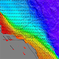
Community Geodetic Model (CGM) Earth surface displacement from GNSS and InSAR
The CGM integrates high-precision GNSS and InSAR data to provide velocities and time series of Earth’s surface movements. Data comes from a number of contributing researchers, institutions and analysis centers.
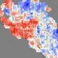
Community Stress Model (CSM) suite of stress and stressing rate models
The CSM provides estimates of stress and stressing rates for various regions of California. The suite of models, derived using a variety of methods and datasets, are presented on a consistent grid.
Community Rheology Model (CRM) 3D ductile rheology of lithosphere in California
The CRM provides a detailed, physics-based 3D model of ductile rheology (rock flow) for Southern California’s lithosphere. The explorer provides an interface to query temperature, pressure, and rheology data.
Community Thermal Model (CTM) estimates of temperature and thermal properties
The CTM provides estimates of temperatures and thermal properties of the southern California lithosphere and asthenosphere. Currently, the CTM includes two models, each based on different methods.
Geologic Slip Rate Database (GSRD) geologic slip rates for CA, NV, and northern Mexico
SCEC’s GSRD centralizes field-derived geologic slip rates crucial for seismic hazard estimates (e.g., NSHM), linked to relevant source publications. As a living archive, it welcomes updates via a user submission form.
Precariously Balanced Rock (PBR) Database field-derived data for PBRs in California
The database contains photographs, locations, and metadata for PBRs, valuable for constraining seismic hazard estimates and validating ground motion predictions. An interactive map viewer facilitates data exploration and querying.
The Statewide California Earthquake Center (SCEC) hosts and develops Community Earth Models (CEMs) that describe the lithosphere and asthenosphere of California and surrounding regions. These models provide an integrated framework for researchers wishing to simulate or study various earthquake-related phenomena throughout the entire Pacific-North American Plate boundary system. Each model is developed by a group of experts using diverse methods and data, with input from various user groups.
Future Directions for SCEC CEM Development
To expand CEM coverage to the entire San Andreas Fault System we will:
Assess the quality and availability of existing models and data.
Refine and merge existing models to create a more comprehensive representation.
Develop multi-scale models to capture the complexity of the entire fault system.
Make CEMs accessible for research and education, and continuously validate them against real-world data.
Open-Source Software and FAIR Data
The Statewide California Earthquake Center (SCEC) prioritizes access to its software tools and data by both the scientific community and the public. Through open-source software and FAIR (Findable, Accessible, Interoperable, Reusable) data practices, we strive for SCEC software and data to remain discoverable, usable, and citable for future research.
Using SCEC Community Earth Models
SCEC’s CEMs are powerful tools for researchers, educators, and anyone interested in earthquakes. We encourage you to explore these valuable resources and integrate them into your work.
Easy Access & User-Friendly Tools
Comprehensive Documentation: Each CEM has a dedicated website with detailed information, data sources, construction methods, and user guides.
Downloadable Archives: Most models offer downloadable files with clear identification through citable DOIs hosted by zenodo.org. Citing these models is highly encouraged to acknowledge the development effort.
Web-Based Explorers: All CEMs have user-friendly “Explorers” – web tools requiring no special software – allowing you to easily interact with, visualize, query, and download model components. These explorers, developed collaboratively by SCEC researchers and software developers, aim to lower access barriers and promote widespread CEM utilization.
CEM Leaders and Software Developers
Scott Marshall
Patricia Persaud
Mei-Hui Su
Phil Maechling
Edric Pauk
Tran Huynh
Proper Acknowledgement & Citations
To ensure proper credit for the development and use of SCEC Community Earth Models, we kindly request that you cite the specific model(s) you utilize in your research or for other applications. This helps track usage and acknowledge the contributions of the many model developers and researchers, who have invested significant effort and expertise to advance SCEC Community Earth Models.
Most models have Digital Object Identifiers (DOIs) on Zenodo. Use the links below to find the appropriate citation: