Accelerating earthquake science discoveries by providing advanced computational resources, fostering collaboration with technical experts, and cultivating a diverse community of skilled researchers.
Priorities for Research and Development
The Statewide California Earthquake Center (SCEC) research computing program leverages advancements in scientific computing and cyberinfrastructure to advance earthquake science, engineering, education, and outreach efforts. This involves
Standardizing data formats and tools (common infrastructure),
Developing detailed geophysical models for California (Community Earth Models),
Providing training in advanced computational techniques (growing community research computing skills), and
Enabling researchers to perform more comprehensive simulations (scenario simulations) and integrate machine learning and big data analysis into their studies.
SCEC Software Developers
Akash Bhatthal
Scott Callaghan
Xiaofeng Meng
Edric Pauk
Fabio Silva
Mei-Hui Su
HPC Partners
DOE / INCITE
Oak Ridge
USC CARC
NSF ACCESS
TACC Frontera
NHERI DesignSafe
AMD
SDSC Expanse
Frontier
A New Earthquake Science Gateway
Quakeworx to streamline research by offering easy access to earthquake simulations, data analysis tools, and collaborative pipelines. READ MORE | NEWS
Computing Partnerships
SCEC collaborates with academic and national HPC providers to leverage new computer architectures, algorithms, and software technology. These partnerships enable large-scale, data-intensive research in earthquake science. Each year, SCEC secures substantial HPC allocations through competitive proposals. Our partnerships also foster sustainable software practices and data archival solutions.
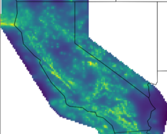
CEMs are collaborative platforms featuring community-contributed data, models, and tools for earthquake system analysis. They enable 3D visualization, data exploration, sharing, and integrated modeling.
Community Fault Model (CFM) 3D geometric representations of faults in California
CFM is an object-oriented, 3D representation of active faults in California, including geometries, depths, and slip potential. Explore and download data for use in fault system modeling, seismic hazard analyses, and many other applications.
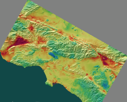
Unified Community Velocity Model (UCVM) software for accessing seismic velocity models
A standard interface to multiple seismic velocity models that can be used to create velocity meshes for 3D wavefield simulations. UCVM is used by researchers working with Earth material properties on regional or local scales.
Community Geodetic Model (CGM) Earth surface displacement from GNSS and InSAR
The CGM integrates high-precision GNSS and InSAR data to provide velocities and time series of Earth’s surface movements. Data comes from a number of contributing researchers, institutions and analysis centers.
Community Stress Model (CSM) suite of stress and stressing rate models
The CSM provides estimates of stress and stressing rates for various regions of California. The suite of models, derived using a variety of methods and datasets, are presented on a consistent grid.
Community Rheology Model (CRM) 3D ductile rheology of lithosphere in California
The CRM provides a detailed, physics-based 3D model of ductile rheology (rock flow) for Southern California’s lithosphere. The explorer provides an interface to query temperature, pressure, and rheology data.
Community Thermal Model (CTM) estimates of temperature and thermal properties
The CTM provides estimates of temperatures and thermal properties of the southern California lithosphere and asthenosphere. Currently, the CTM includes two models, each based on different methods.
Geologic Slip Rate Database (GSRD) geologic slip rates for CA, NV, and northern Mexico
SCEC’s GSRD centralizes field-derived geologic slip rates crucial for seismic hazard estimates (e.g., NSHM), linked to relevant source publications. As a living archive, it welcomes updates via a user submission form.
Precariously Balanced Rock (PBR) Database field-derived data for PBRs in California
The database contains photographs, locations, and metadata for PBRs, valuable for constraining seismic hazard estimates and validating ground motion predictions. An interactive map viewer facilitates data exploration and querying.
The Center prioritizes access to its software tools and data by both the scientific community and the public. Through open-source software and FAIR (Findable, Accessible, Interoperable, Reusable) data practices, we strive for SCEC software and data to remain discoverable, usable, and citable for future research.
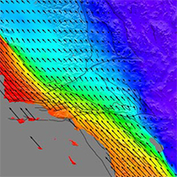
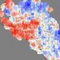
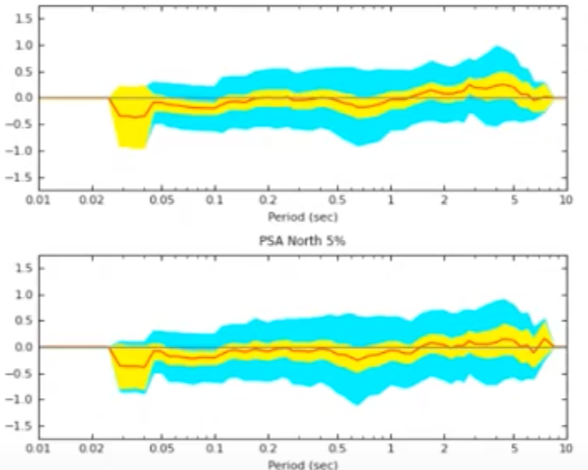
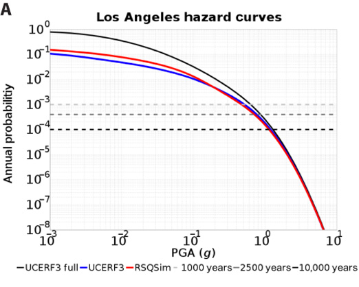
Simulation Validation
Broadband Platform (BBP)
Simulate, compare, and validate broadband (0-20+ Hz) earthquake ground motions at regional scales.